
Snow Emergencies
Township of Cranford
Snow Removal Operations Overview
Residents and businesses often have some questions as to how the Township and our partners at County DPW and NJ DOT clear the roadways.
- The Township typically initiates plowing operations after snow accumulations exceed three inches on paved surfaces. For lower-end snow accumulations, salting operations are conducted to improve road conditions.
- Roadways in town are generally prioritized in three categories for snow removal.
- Primary snow routes are the first priority, and they are designated as such because they are main roadways, or roads which provide primary access into interior residential neighborhoods, or roads that otherwise serve school buildings or other infrastructure. The primary goal is to maintain the ability of emergency services to access all neighborhoods of the Town during and shortly after the storm event. Some of the primary roadways are County Roadways, and are plowed by the County DPW. North Avenue is a State Highway, and is plowed by NJ Department of Transportation.
- Secondary Roadways are the roadways which are feeders to the Primary roadways. These serve mainly residential neighborhoods.
- Tertiary Roadways are generally dead-end streets and cul-de-sacs, and other roads which connect off of Secondary roads. These streets often require some specialized attention and equipment for snow removal.
- It could take several hours after snowfall ends for resources to clear your street. This depends on the timing of the storm, the extent of snowfall, and other operational considerations.
- The main priorities with the snow removal operation are keeping our Township staff safe, ensuring effective snow removal with minimal damage to property or equipment, and ensuring access for emergency vehicles throughout the Township.
What can Residents do to help expedite snow removal operations?
- Remove cars from roadways, especially along snow routes.
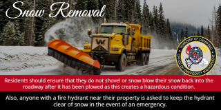
- Do not throw snow onto the street.
- Clear out fire hydrants near your home
- Stay off roadways as much as possible.
Snow Emergency Route and Snow Ordinance:
In accordance with the provisions of § 410-30, no person shall park a vehicle upon either side of any of the streets or parts of streets thereof listed below, whenever snow has fallen and there is an accumulation of three inches or more of snow on any street or highway.
Name of Street |
Limits |
|---|---|
Bloomingdale Avenue | From Elizabeth Avenue to the Kenilworth boundary line |
Brookside Place | From the Garwood boundary line to Orchard Street |
Brookside Place | From Orchard Street to Harvard Road |
Burnside Avenue | From Lexington Avenue to Lincoln Avenue West |
Centennial Avenue | From the Linden boundary line to South Avenue East; a yield right-of-way sign having sides 36 inches in length shall be installed on Raritan Road facing westbound traffic |
Central Avenue | From Springfield Avenue to Craig Place |
Cranford Avenue | From Forest Avenue to Elizabeth Avenue |
Cranford Terrace | From Munsee Drive to Centennial Avenue |
Denman Road | From Lexington Avenue to Fairfield Street |
Eastman Street | From Holly Street northerly to Pittsfield Street |
Eastman Street | From North Avenue West northerly to Holly Street |
Elizabeth Avenue | From North Avenue East to North Union Avenue |
Elm Street | From High Street to Centennial Avenue |
Gallows Hill Road | From Brookside Place to the Westfield boundary line |
Henley - Dunham Avenue | From Riverside Drive to Locust Drive |
High Street | From South Avenue East to Hickory Street |
Hillcrest Avenue | From Lexington Avenue to Williams Street |
Kenilworth Boulevard | From the Westfield boundary line to the Kenilworth line |
Lexington Avenue | From Lehigh Valley Railroad to the Garwood boundary line |
Lexington Avenue | From Raritan Road to Alan O'Kell Place |
Lincoln Avenue East | From Centennial Avenue to South Avenue East |
Lincoln Avenue East | From High Street to Centennial Avenue |
Lincoln Avenue East | From Walnut Avenue to High Street |
Lincoln Avenue West | From South Avenue West to Walnut Avenue |
Manor Avenue | From North Union Avenue to Orange Avenue |
Normandie Place | From Riverside Drive to LaSalle Avenue |
North Lehigh Avenue | From Centennial Avenue to Mansion Terrace |
North Union Avenue | From North Avenue to Springfield Avenue |
North Union Avenue | From Springfield Avenue to Lenox Avenue |
Orange Avenue | From Springfield Avenue to the Kenilworth boundary line |
Orchard Street | From North Avenue West to Indian Spring Road |
Raritan Road | From Centennial Avenue to Walnut Avenue |
Raritan Road | From the Linden boundary line to Centennial Avenue |
Retford Avenue | From Lexington Avenue to Lincoln Avenue |
Retford Avenue | From Lincoln Avenue to Cherry Street |
Riverside Drive | From Claremont Place to Edgar Avenue |
Riverside Drive | From Springfield Avenue to Claremont Place |
South Avenue East | From the Roselle boundary line to South Union Avenue |
South Avenue West | From South Union Avenue to the Garwood boundary line |
Springfield Avenue | From North Avenue East to Kenilworth Boulevard |
South Union Avenue | From Lexington Avenue to Lincoln Avenue |
South Union Avenue | From Lincoln Avenue to South Avenue |
Walnut Avenue | From Raritan Road to South Avenue East |
Walnut Avenue | From South Avenue East to the Transit Railroad Bridge |
West End Place | From Orchard Street to Springfield Avenue |
West Holly Street | From the Garwood boundary line to Orchard Street |
Snow Emergency Map can be found here: https://www.cranfordnj.org/sites/g/files/vyhlif436/f/uploads/cranford_snow_emergency_map.pdf
NWS: Probabilistic Winter Weather Forecasts: Probabilistic Winter Weather Forecast